The sound maps that predict poachers' movements

 Alamy
AlamyDigital monitoring tools are helping rangers protect wildlife in South America's Atlantic Forest. Could sound-based maps pin down the poaching threat?
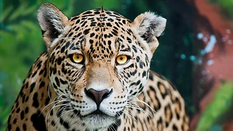
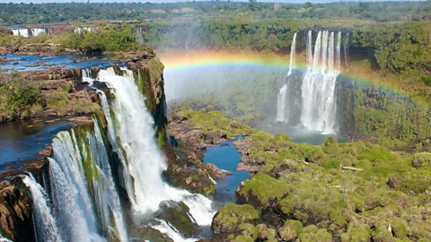
In the Upper Paraná Atlantic Forest lies the world-renowned Iguazu Falls. On one side of the towering cascades is the Iguazú National Park of Argentina, on the other is the Iguaçu National Park of Brazil. Greened by over 2,000 plant species, the landscape is home to an array of creatures, including the charismatic jaguar. And to the million-plus tourists who visit each year, the region may appear to be part of a vast expanse of thriving biodiversity.
But for those like Yara Barros, who know it well, Iguazú's parks are in fact "an island of life in the midst of deforestation". Barros is a biologist and coordinator of Onças do Iguaçu, a Brazilian jaguar conservation project. She explains that in the Atlantic Forest's entire 140,000 sq km (54,054 sq miles), there are only 300 jaguars. As many as one-third now live inside the narrow 2,400 sq km (927 sq miles) corridor protected by the parks.
More widely too, jaguars today are under some form of threat across almost their whole range, which stretches from the south-western US to northern Argentina. According to a study by the Cites secretariat, which oversees the international treaty on wildlife trade, these threats are also increasing. As deforestation and incursions by roads and agriculture expand, the number of prey animals decreases and poachers gain ever greater access to remote areas.
Nor are the big cats alone in facing these linked dangers of deforestation and poaching: the overall abundance of Latin America and the Caribbean's monitored wildlife populations has fallen by a catastrophic 94% in recent decades, according to the 2022 Living Planet Report. "Control of hunting is urgent, as poachers enter to hunt other animals and end up killing the jaguar eventually," says Barros.
 Getty Images
Preventing the illegal hunting of any creature is hard, however, especially when relatively small numbers of park staff are often responsible for patrolling large areas. So researchers and park-staff in Iguazu have been exploring new means of predicting where poachers might strike – and they are turning to new kinds of mapping technology for help.
Sign up to the Future Earth newsletter to get essential climate news and hopeful developments in your inbox every Tuesday from Carl Nasman. This email is currently available to non-UK readers. In the UK? Sign up for newsletters here.
Mapping the problem
Back in the early 2000s, rangers still relied on and filled in field reports by hand, says Cecilia Belloni, a long-serving park ranger stationed on the eastern border to Argentina's Iguazu National Park. "We now use satellite phones in the forest, along with the Spatial Monitoring and Reporting Tool (Smart) system and Quantum Geographic Information System for spatial analysis."
"Geographic Information Systems can make the rangers' tours more efficient," Belloni explains, by allowing the ranger teams to better log data and quantify any relevant information they notice. That could include everything from fires to deforestation and land-use change, both within and beyond the protected areas.
The Smart application on their phone or tablets then helps the rangers sift and standardise all the new data they record. This free, open-source set of software and analysis tools has been especially designed to assist conservation managers with their surveillance work. It first became available to Argentine rangers in 2014, during a training trip to Thailand, and was then tested with park rangers in Iguazu.
You might also like:
Now 20 of the country's 50 parks are using the Smart system, says Leónidas Lizarraga, geographic information services technician of the Argentine Administration of National Parks (APN). By logging geolocated photos of every shotgun shell found, he explains, the rangers can establish a hunting trail. "[This] eventually allows them to follow its route and find people who are beyond the area of public use."
Poachers also often use fruit trees as bait, notes Belloni, such as the timbó from which the tapir feeds. So by marking (or "georeferencing") the location of these trees on the software, as well as their fruiting season, the rangers can also better plan their patrols.
The APN aims to expand Smart's use to all the remaining parks by early 2024, says Federico Rodríguez Mira, park ranger of the Iguazu National Park, in charge of the area of operations. "The APN intends to acquire electronic equipment such as smartphones and tablets resistant to extreme weather conditions, with the aim of substantially improving data collection in the field and thus favouring decision making."
Listening to the forest
But Smart technology is also only as helpful as the data available to inform it. In 18 years of monitoring the jaguar population in the Iguazu parks, the number recorded peaked in 2018 at 105, but has since fallen to around 93. "The whole operational situation improved a lot, but the reality is that we are [still] faced with a high number of hunters," says Belloni. Conservationists in Iguazu are thus constantly on the look-out for new ways to map and predict poaching hotspots.
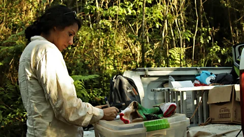
One additional mapping tool could be based on audio. For seven months from August 2018, researchers from Argentina and Brazil used acoustic monitoring methods to map poaching hotspots inside the two national parks. Backed by the Yaguareté Project (the Argentine equivalent of the Onças do Iguaçu's jaguar conservation project), the research team placed 20 audio recorders inside and around the Iguazú area.
 Constanza Pasian
The study covered an unprecedentedly large 4,637 sq km (1,790 sq miles) area and, by situating the automatic recorders high on trees out of sight of poachers, the team were able to record gunshot sounds up to 2km (1.2 miles) away from each location. After seven months, they had captured gunshots at 43 sites out of 90, with a range of one to 68 shots per station.
The researchers then used this information to generate a predictive map of poaching activity. They also validated their model with field trips to look for physical evidence, such as bullet cartridges and cut vegetation, and confirmed that the predictive map was 82% reliable, says Julia Martínez Pardo, a conservation biologist at the Institute of Subtropical Biology in Misiones, Argentina, who led the study.
The practical application of this system could, in future, further help the parks' rangers efficiency. By cross-referencing the acoustic monitoring data with the ranger's existing patrol routes, says Pardo, the park staff could establish whether their current tours coincide with the places with greatest gunshot activity. If the maps don't match, then the patrols could be adjusted.
Sergio Moya, the electronic engineer and designer at the National University of Misiones who came up with the algorithm used by Pardo's team, says that "today the amount of resources allocated to conservation is very scarce, so inevitably we have to rely on technology to optimise actions and concentrate efforts where it is really needed".
There is also already proof that such a combination of data sources can produce tangible results. Since 2017, the international non-profit Panthera has been deploying a similar acoustic monitoring technique to support their anti-poaching efforts in Guatemala and Honduras, in Central America. Within three years, the local authorities were able to use the acoustic data to arrest three poachers.
Bárbara Escobar, Panthera's coordinator for Guatemala, explains that their work in the Sierra del Caral border area is especially important to jaguars, since genetic studies show that the connectivity of the species across the Mesoamerican region is being lost. "Although it has been found that hunting in the area is focused on the jaguar's prey, this is also a threat to the big cat – since the loss of prey, as well as the deforestation of its habitat, contributes to its loss of connectivity," says Escobar.
Beyond the map
Back in Iguazú, combining acoustic and visual sensors would help ranger teams to focus their efforts, says Mira, the ranger. As would the addition of drones, which can also assist surveillance in difficult-to-access areas.
Consequently, Mira says that the APN has plans to incorporate these and other new technologies in 2024. The hope is that these will help target their poaching surveillance efforts – and free up time to monitor and assist the more than one million visitors who visit the park each year.
 Julieta Maccarino
But as Pardo's study also concluded, there is only so much that improved mapping and patrolling can do to prevent poaching. Their model showed that the key determinants of poaching's occurrence were the distance to park rangers' patrol posts (which act as deterrents), as well as the proximity and accessibility of human settlements (which offer convenience). When access from towns and cities is easier, poaching is higher.
Tackling the threats to wildlife at source is thus also essential. Especially since Argentina's newly elected president is seeking to dismantle environmental protections.
Pardo's study recommends, among other measures, improving the socio-economic situation of local people. Yet while tourism can help provide new incomes, it can also add to the challenge by adding infrastructure that aids the poachers.Ivan Baptiston, environmental analyst and former head of the Iguaçu Park in Brazil, says that although recent plans to reopen a road in the middle of the protected areas was halted, Brazil's former president leased a new concession for the park before leaving office.
"The new proposals are still under discussion, but they would authorise new balconies and bridges in the already saturated Cataratas [tourist] circuit that divides the jungle surrounding the falls," says Baptiston, who worries about the impact on the area's biodiversity.
Poachers' methods are also becoming more sophisticated. In Brazil, notes Barros, hunters make use of timers to release bait to attract prey, in addition to silencers to throw off patrols, and in some cases GPS and walkie-talkies.
And while fines for poachers can be considerable – with one poacher in Argentina fined 3,770,000 Argentine pesos; equivalent to almost $11,000 (£9,000), or 29 times the average Argentine minimum wage, at the time of the offence – many still evade prison time says Nicolás Lodeiro Ocampo, co-founder and executive director of the Argentinian non-profit Red Yaguareté. "In Argentina, any felony with a sentence of less than three years is prison-free, hence we need to upgrade the sentences to at least four or eight years," he says.
Lucía Lazzari, terrestrial landscapes coordinator at the Wildlife Foundation Argentina, believes that efforts to introduce new technological tools, such as Smart and acoustic monitoring, must always be part of a suite of wider conservation efforts. These should include work on conserving, restoring and connecting habitats, stopping illegal deforestation and forest degradation, as well as promoting sustainable productive practices.
"Deforestation is the most important threat that our jungle faces today," says Lazzari. "[It] affects not only fauna like the jaguar, but also the people who live and depend on [the forest's] ecosystem services."
Using high-tech maps to improve ranger patrols must therefore be combined with work with local communities, says Barros. If changes aren't made, she fears the worst: "I don't want to live in a world where the jaguar's golden eyes don't exist anymore."
--
If you liked this story, sign up for The Essential List newsletter – a handpicked selection of features, videos and can't-miss news delivered to your inbox every Friday.
Join one million Future fans by liking us on Facebook, or follow us on Twitter or Instagram.